We’re huge fans of Eno River State Park in Durham and Orange counties (near Durham and Hillsborough) and want to share our favorite hikes with you. If it’s your first time visiting, this state park may seem overwhelming at first, with its handful of access points and 17 designated Eno River State Park trails.
In this guide, we’ll share more details about all 30-plus miles of trails, broken down by access areas. Our guide will also cover Eno River trails that fall outside the park’s boundaries.
Here’s how we’ve organized the guide, in case you’re looking for something specific:
- Cole Mill Access Point
- Fews Ford Access Point
- Pump Station Access Point
- Cabe Lands Access Point
- Pleasant Green Access Point
- Bonus Eno River Trails (Occoneechee Mountain, Little River, and More!)
Read More: Hiking Near Raleigh, Durham, and Chapel Hill (25 of the Best Trails for All!)

Leave No Trace Reminder

While visiting Eno River State Park (or any public space in North Carolina), we ask you to PLEASE leave no trace. Pack in, pack out, and please do not litter.
If you’d like to lend a helping hand, bring a grocery bag of your own and pick up any trash that you see!
Safety Reminders
- Most of these Eno River State Park trails are for all levels of hikers, difficulty-wise. Some are lengthy trails (ex. Cox Mountain and Laurel Bluffs) but most are under two miles in distance.
- When hiking along the river, there are occasional dropoffs, so please be careful and keep away from the edge of the riverbank is possible. For any applicable trails, we’ll add an extra note of caution. However, we want to remind you that safety is your responsibility when enjoying these hikes.
- Flooding is a possibility at Eno River State Park, especially in lower lying areas.
- Venomous snakes do call the park “home,” so please proceed with caution, especially during warmer months and if you’re traveling with young children or pets.
- Also, if you’re bringing a dog along for your hike, North Carolina State Parks require them to be kept on a leash.
- If you want an Eno River State Park Map or Eno River Trail Map, you can find them here.
Eno River State Park Trails (Cole Mill Access Point)
Cole Mill Access Point Address: 4390 Old Cole Mill Road, Durham, NC
Cole Mill Access Point is closest to I-85 (Exit 173) and is a few miles down Cole Mill Road from the interstate near Eno River Durham, NC.
If you’re driving from that direction, you’ll pass Picnic, one of our favorite restaurants in Durham.
That place cooks excellent barbecue, fried chicken, and everything else that’s on the menu. A meal there pairs nicely with these Eno River State Park trails found at the Cole Mill Access Point.
Read More: North Carolina Barbecue: 27 Iconic Restaurants, History, and More
Bobbit Hole Trail
Trail Distance: 1.65 Mile Loop (Red Circle Blaze)
Bobbit Hole Trail is accessed by first starting on the Cole Mill Trail. The quickest way to connect is by hiking counter-clockwise (southwest) on the Cole Mill loop.
The trail splits nears its beginning with one option that follows the river and another that eventually crosses Piper Creek. Either direction meets at the beautiful swimming hole and fishing spot known as Bobbit Hole.
You can either backtrack the way you came in or follow the loop.
Like with many Eno River State Park trails, this one will run across the river from another trail. In this case, Bobbit Hole Trail (and Cole Mill Trail, too) runs across from the Laurel Bluffs Trail (also, part of the Mountains to Sea Trail).
Read More: Outdoor Things to Do in Durham
Cole Mill Trail
Trail Distance: 1 Mile Loop (Yellow Circle Blaze)

Cole Mill Trail is one of the easiest and best trails in Eno River State Park. There’s a little bit of incline, descent, and roots along the way.
Stay aware and enjoy this hike along the river and through the woods. As with Bobbit Hole Trail, when hiking along the river, you’ll be hiking across from the Laurel Bluffs Trail.
As we also mentioned, Cole Mill Trail connects with Bobbit Hole.
Read More: 100+ of the Best Hiking Trails in North Carolina
Dunnagan Trail
Trail Distance: 1.8 Mile Loop (Red Circle Blaze)
Dunnagan Trail starts from the Pea Creek Trail and is a loop along the river and on a nearby ridge. You’ll be hiking directly across the Eno River from Pump Station Trail.
Unfortunately, Pea Creek Trail has been closed since June 2020 and access to this trail is currently closed.
Pea Creek Trail
Trail Distance: 1.3 Mile Loop (Blue Circle Blaze)
Starting from the south end (or far end) of the parking area, Pea Creek Trail runs under the bridge on Cole Mill Rd loops along the river, Pea Creek, and through the forest.
Pea Creek Trail has been closed since June 2020 and will hopefully recover from the storm erosion and damage.
Eno River State Park Trails (Fews Ford Access Point)
Few Ford Access Point Address: 6101 Cole Mill Road, Durham, NC
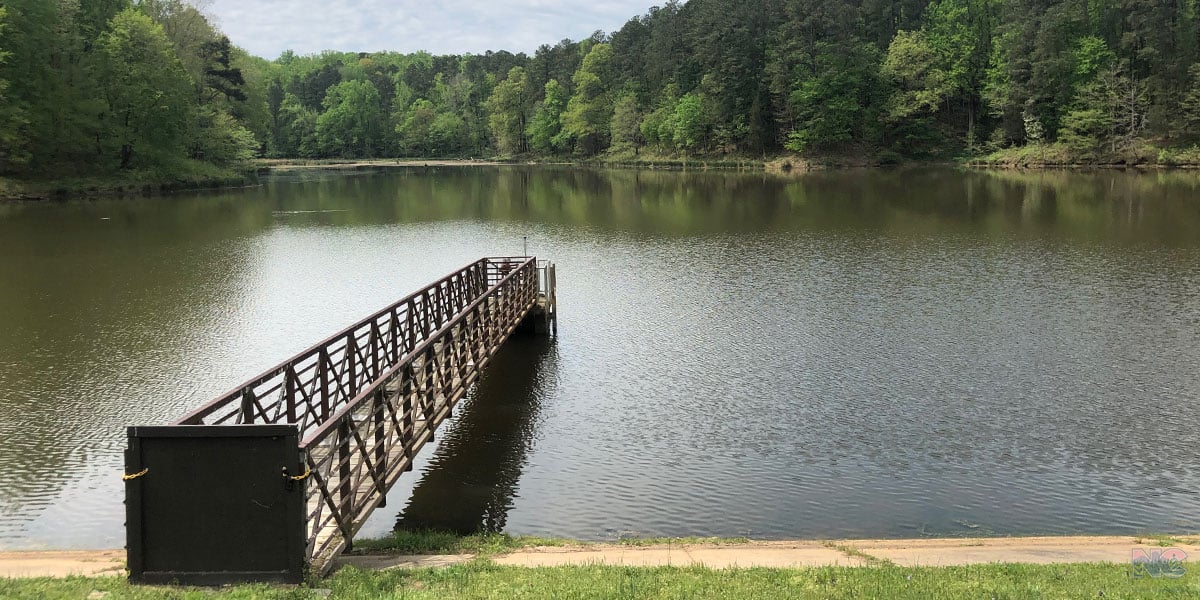
Fews Ford is one of the more popular Eno River State Park access areas. It sits at the end of Cole Mill Road, after its intersection with Pleasant Green Road.
At Fews Ford, you’ll find the historic Piper-Cox House/Museum, the park office, and a popular swimming hole.
Many people come here to swim on hot days, especially during summer break. If you’ve come to hike on a warm day, get here early because the parking areas (especially the first lot) can fill up quickly.
Here are some of our favorite trails at this access point.
Read More: Central North Carolina (and 100+ Amazing Places to Visit)
Buckquarter Creek Trail
Trail Distance: 1.50 Mile Loop (Red Circle Blaze)

Buckquarter Creek might be my favorite of all Eno River State Park trails. It starts at Few’s Ford and immediately splits, though the riverside trail is easier to follow.
Before looping away from the river, this is where you’ll find some of the Eno’s most beautiful rapids. Afterward, you’ll ascend through a forest ridge, with a mix of ups and downs before returning to the starting point.
You can add distance to your Buckquarter Creek Trail hike through multiple connections:
- The Holden Mill Trail
- Fieldstone Trail
- Ridge Trail
- Shakori Trail
- Knight Trail
- Piedmont Trail
Read More: 50+ Easy Day Trips from Fayetteville (Great Getaways!)
Cox Mountain Trail
Trail Distance: 3.75 Mile Loop (Blue Circle Blaze)

Cox Mountain Trail is well-loved for its picturesque Eno River suspension bridge but also for the diverse terrain you’ll find while hiking it. The trail begins as an out-and-back, with a split for the Eno Trace Trail, before you cross the river.
After crossing the river, you can take a walk to the historic cabin that’s just off the trail before continuing on.
When you get back on the trail, you’ll head through the woods before encountering the first of two loop options. I prefer the second option, which ends with a descent back to the bridge.
On the loop, you’ll either be hiking in the tree-covered forest or during colder months, on a more exposed ridge that offers views of the river below.
Following that second loop intersection, the trail intersects with Fanny’s Ford Trail, which you can use to spend more time walking along the river.
Cox Mountain is also one of the places that has official Eno River State Park camping areas.
Read More: 25 of the Most Amazing Winter Hikes in North Carolina
Eno Trace Trail
Trail Distance: 0.5 Mile Loop (Red Circle Blaze)
As we mentioned, the Eno Trace Trail splits off from Cox Mountain Trail near the parking area. This short loop runs along the river and back toward the picnic tables.
There are informational signs along the way, explaining ecology of the Eno River.
Fanny’s Ford Trail
Trail Distance: 1 Mile Loop (Purple Circle Blaze)

Fanny’s Ford is a nice loop that is accessible from the Eno River Cox Mountain Trail. It will take you to the other side of Fews Ford and the Buckquarter Creek Trail along the river.
This scenic trail is a great addition to your Cox Mountain Trail hike if you’re seeking a lengthier trek.
Read More: Free Things to Do in Durham
Fieldstone Trail
Trail Distance: 0.6 Miles One Way (Blue Blaze)
Fieldstone is the first of a few trails we mentioned that are reached via the Buckquarter Creek Trail. This short trail connects Buckquarter Creek to the Ridge Trail at the park boundaries.
Holden Mill Trail
Trail Distance: 2.6 Mile Loop (Yellow Circle Blaze)

The Holden Mill Trail starts from the Buckquarter Creek Trail and loops around the stone remnants of the historic Holden’s Mill site and along the river. Like Buckquarter Creek Trail, you’ll find rapids along Holden Mill Trail.
Knight and Piedmont Trails
Trail Distance: 0.5 Miles One Way (Red U Blaze)
Knight and Piedmont are the two most unique Eno River State Park trails because their primarily used by residents of property adjacent to the park. However, park visitors are welcome to use them.
However, please respect signage and enter private property only if you have permission.
Ridge Trail
Trail Distance: 1.25 Miles One Way (Blue U Blaze)

The historic Ridge Trail is accessed via the Fieldstone Trail or the Buckquarter Creek Trail. You’ll find the remains of three homes built in the 19th century along this path.
Like the Knight and Piedmont trails, this one leaves Eno River State Park. Enter private property ONLY if you have permission to do so.
Shakori Trail
Trail Distance: 1 Mile One Way (Yellow U Blaze)
The Shakori Trail connects with the Ridge Trail twice to make a loop. You’ll also leave the park on this trail.
Please do not enter private property unless you have permission to do so.
Eno River State Park Trails (Cabe Lands Access Point)
Cabe Lands Access Point Address: 4950 Howe St, Durham, NC
The Cabe Lands Access Point sits between the Cole Mill and Pleasant Green access areas. From Cabe Lands, you can reach the popular quarry and some of our favorite Eno River State Park trails.
Read More: Day Trips from Raleigh
Quarry Trail
Trail Distance: 0.8 Mile Loop (Blue Circle Blaze)

Speaking of the quarry, the Quarry Trail is a loop that connects the westernmost section of the Laurel Bluffs Trail to the Cabe Lands Trail. The highlight of this trail is the quarry, which you can circumnavigate.
Along the way, you’ll see numerous signs warning against swimming in the quarry and dangerous dropoffs around the quarry. Sadly, deaths are reported here each year, especially in the summertime.
Please proceed with caution when you visit and stay safe.
Cabe Lands Trail
Trail Distance: 1.2 Mile Loop (Red Circle Blaze)

Cabe Lands is a loop that you can start from the Cabe Lands Access Point or from the Quarry Trail. You’ll descend to the river from either direction and ascend on your way back to the starting point.
You can notice stone foundations while hiking this trail, especially in winter.
Eno River State Park Trails (Pleasant Green Access Point)
Pleasant Green Access Point Address: 4770 Pleasant Green Road, Durham, NC
The Pleasant Green Access Point is not far from US-70 near Hillsborough. Along the river, it’s between Fews Ford and Cole Mill.
You can start the multi-section Laurel Bluffs trail here and can reach the quarry in about 1.5 miles.
Laurel Bluffs Trail
Trail Distance: 6.1 Miles One Way (Yellow Circle Blaze)

The Mountains-to-Sea Trail runs through Laurel Bluffs Trail, also the longest of all Eno River State Park trails. It is broken into three sections, with connections to the Quarry Trail, Cabe Lands Trail, and Pump Station Trail from west to east.
Laurel Bluffs Trail ends at each connection and picks back up afterward. While it is officially 6.1 miles long, you’d need to hike about 10 miles from the Pleasant Green Access Point to the trail’s end at Guess Road.
Eno River State Park Trails (Pump Station Access Point)
Pump Station Access Point Address: 4023 Rivermont Road, Durham, NC
The Pump Station Access Point offers an opportunity to hike the Pump Station Trail and connect with the Laurel Bluffs Trail.
Pump Station Trail
Trail Distance: 1.5 Mile Loop (Red Circle Blaze)

Pump Station is one of the more non-descript trails of Eno River State Park, but one of the most popular. It’s a short loop, full of beautiful wildflowers in spring, and a cool look at an abandoned pump station’s ruins, hence the name.
As we mentioned, you can connect to the Laurel Bluffs Trail and hike 2.5 miles west toward Cabe Lands or 2.2 miles east to the park’s boundary at Guess Road.
Bonus Eno River Trails
Eno River Trails don’t end beyond the state park’s boundaries. Others are part of our NC State Parks system or local and regional municipalities and organizations.
The Eno River Association is largely responsible for these trails, as the non-profit has protected more than 7,400 acres of natural land. This includes land inside today’s Eno River State Park and a few of the other parks we’ll mention shortly.
Currently, the organization owns 357 acres and holds easements on 1,100-plus more acres.
Read More: The Best Breakfast in Durham and 15+ Essential Restaurants to Start Your Day!
Confluence Natural Area
Named for the meeting of the East and West Forks of the Eno, Confluence Natural Area is a historic mill site with multiple rare plant species. You can visit 7 days a week, thanks to the Eno River Association, its volunteers, and supporters for preparing the park.
You can access two connected trails here, including Shepperd Mill (0.5 miles one way) and Two Forks (1.75 miles one way).
Hillsborough Riverwalk

The Riverwalk in Hillsborough is home to one of our favorite Eno River trails. The paved, hilly walkway is lined with informational placards that detail the Eno’s importance and the life that thrives here.
This trail is just under two miles long and runs from Gold Park on Dimmocks Mill Road in downtown Hillsborough. It is also part of the Mountains-to-Sea.
Read More: Day Trips from Durham
Historic Occoneechee Speedway Trail
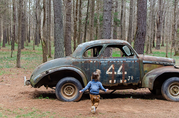
The Historic Occoneechee Speedway Trail is yet another great hike along this river! The mile-long oval loop (Speedway Trace) was the first NASCAR Superspeedway and was once considered one of the most dangerous tracks.
You can still see remnants of several cars, the stands, and walk the wide tree-covered path that once made racing history.
Speedway Trace is among four miles of trails, which also includes the Spectator Trace Loop Trail that runs above the track.
Read More: How to See Speedway Christmas in Concord
Little River Regional Park

Little River Regional Park is not technically along the Eno River, but the Little River is within the Eno River Basin. It’s also one of many lands protected by the Eno River Association and a few miles down the road from the Eno River State Park boundary.
You can hike five different trails here, including a 7-mile mountain bike trail. Here are the five hiking trails at Little River:
- Bird Trail (0.5 miles)
- Homestead Trail (0.2 miles)
- Ridge Trail (0.84 miles)
- North River Loop Trail (1.2 miles)
- South River Loop Trail (1.4 miles)
Read More: Things to Do in Chapel Hill
Occoneechee Mountain State Natural Area

Occoneechee Mountain State Natural Area is a smaller NC State Parks-managed site at about 190 acres. However, it’s special for having one of the few peaks in the area.
Occoneechee Mountain is said to be the highest point between Hillsborough and the coast. To access the top, you’ll need to hike from either the Occoneechee Mountain Loop (2.2 miles) or the Chestnut Oak Trail (0.9 miles one way) and connect to the Overlook Trail (0.10 miles).
The view is worth either hike. You’ll get a look at the Eno River below, wonderful foliage during fall peak, and a clearer view of Hillsborough during the winter months.
Read More: Colorful Fall Hikes in North Carolina (+ 20 Beautiful Places to Explore!)
Penny’s Bend Nature Preserve

Penny’s Bend Nature Preserve is managed by the NC Botanical Garden in Chapel Hill, even though it sits on the northern outskirts of Durham.
Due to unique geological factors, Penny’s Bend is home to rare plants that grow in a soil that typically found in the midwestern US.
The Eno River surrounds this 84-acre preserve on three sides and 2.5 miles of trails (Ridge Trail and Riverbend Trail) will take you around and through this wonderful protected space.
Read More: The Most Beautiful Botanical Gardens in North Carolina
West Point on the Eno

West Point on the Eno is a special place, located off N Roxboro St/US 501 N in North Durham. On hot summer days, you can glance past the iconic bridge and see hordes of people wading in the water early in the morning.
There’s a lovely historic grist mill to visit, picnic tables, and a shelter. The Eno River Association also holds its annual Festival for the Eno on the 404-acre protected space each July.
Beyond all those fun ways to enjoy this park, there are five miles of scenic trails to explore here:
- Buffalo Trail (0.4 miles)
- Eagle Trail (1.8 miles)
- Laurel Cliffs Nature Trail (0.37 miles)
- Sennett Hole Trail (0.15 miles)
- South River Trail (0.52 miles)
What are your favorite Eno River Trails to explore? If you’ve got one (or more) to share, let us know in the comments section below or by email!